ArcGIS Review
 OUR SCORE 96%
- What is ArcGIS
- Product Quality Score
- Main Features
- List of Benefits
- Technical Specifications
- Available Integrations
- Customer Support
- Pricing Plans
- Other Popular Software Reviews
What is ArcGIS?
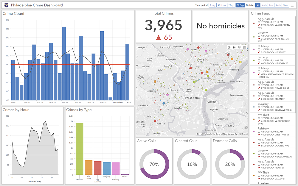
ArcGIS, the powerful mapping and analytic solution, is designed to help users explore, analyze, and share location-relevant insights. It is packed with contextual tools that are used in spatial reasoning. This, importantly, includes mapping of educators, developers, industries plus government agencies worldwide. The program uses a powerful Geographic Information System (GIS) to help users solve problems. This set of tools is quite unique as it contains features such as data collection and management, 3D GIS, imagery and remote sensing, spatial analytics, and mapping and visualization. These powerful tools are used by users to analyze location-sensitive decisions. It helps decisionmakers visualize the context of entities, locations, and processes that their business are connected to.Product Quality Score
ArcGIS features
Main features of ArcGIS are:
- 3D GIS
- Data Collection & Management
- Imagery and Remote Sensing
- Mapping and Visualization
- Real-Time GIS
- Spatial Analytics
ArcGIS Benefits
The main benefits of ArcGIS are simplified data visualization, flexible usage, and empowered business decision-making.
The software uses what is called a common visual language or maps that link different organizations. These connections are then rendered to simple visualizations and analytics, making it easier for users to gain insights off of them. These connections can also be used by organizations to connect with other organizations and collaborate with them. This can be done through reports, apps, and maps.
The GIS helps organizations pose questions, visualize data, conduct thorough analyses, and make useful interpretations to infer about the state of things and also make sensible predictions. The GIS ultimately helps users better understand the links between entities, trends, and find behavioral patterns to exploit or avoid. It is a great addition to a decision-makers’ toolkit.
This can be used by both types of organizations: for-profit and non-profit. For-profit organizations can make use of its analytics functionality, the core of the ArcGIS software, to find ideal locations for putting up business facilities. For non-profit organizations like government agencies, ArcGIS can help decision-makers plan for better communities and outcomes for their specific projects. Furthermore, the platform functions in real time. This means users can provide faster responses to unforeseen situations.
ArcGIS is a robust location-based intelligence tool worth considering when the success of your organizational operations rests on good location-based data and analysis.
Technical Specifications
Devices Supported
- Web-based
- iOS
- Android
- Desktop
Customer types
- Small business
- Medium business
- Enterprise
Support Types
- Phone
- Online
ArcGIS Integrations
The following ArcGIS integrations are currently offered by the vendor:
No information available.
Video
Customer Support
Pricing Plans
ArcGIS pricing is available in the following plans: