Esri CityEngine Review
- What is Esri CityEngine
- Product Quality Score
- Main Features
- List of Benefits
- Technical Specifications
- Available Integrations
- Customer Support
- Pricing Plans
- Other Popular Software Reviews
What is Esri CityEngine ?
Esri City Engine is a standalone, easy-to-use 3D editing and visualization application developed by EsriR&D for individuals and businesses in the fields of general 3D content production, GIS (Geographical Information System), entertainment, simulation, architecture, and urban planning. It is a robust concept design and modeling system that empowers users to easily generate and maintain 3D models of buildings and city scenes. It also shares outputs to ArcGIS online. Esri City Engine delivered unmatched 3D visualization power that aids users in tracking the relationship between projects and inspect their feasibility before actually implementing them. The application also allows shows the conceptual representation of buildings to users, giving them enough data to make an informed decision that could benefit the community for years to come. It uses a procedural approach to modeling for every project and uses three key aspects in accomplishing tasks namely procedurally-defined rules, feature geometry, and feature attributes). There are two license levels that come with the platform, Basic and Advanced, and can work optimally on Mac, Linux, and Windows devices.Product Quality Score
Esri CityEngine features
Main features of Esri CityEngine are:
- Façade texturing
- Share smart 3D city scenes
- Script-based export
- OpenStreetMap Import
- 3D plant library
- Visualize 3D zoning rules
- CryEngine SDK
- Esri shapelife support
- KML support
- Esri File geodata support
- Measure tools
- Rule package (RPK) creation
- Integrated with ArcGIS
- 3D mouse support
- Parametric city design tools
- Python scripting interface
- Instant report generation
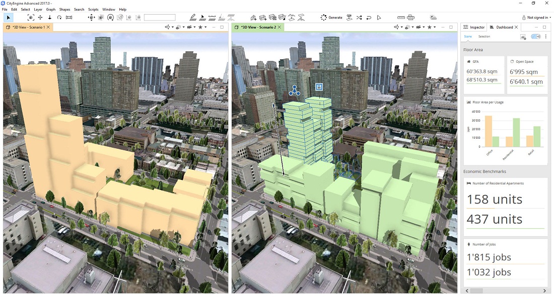
- Customizable dashboards
- Local edits for procedural models
- Terrain and map support
- CGA rule editor
- Get map data
- Scenario-based planning
- City wizard
Esri CityEngine Benefits
The main benefits of Esri City Engine are its highly customizable user interface, capability to design and create a 3D urban scene based form GIS data, and dynamic city layout feature. Here are more details:
Customizable UI
Esri CityEngine is equipped with a customizable user interface, which means that it adapts to the current tasks at hand. No matter the aspect of development users are currently working on, be it editing with live feedback, studying reports of current developments, rule creation, etc., the system makes it easier. The interface allows easier management of repetitive tasks, generating reports in the preferred format, and automating specific actions.
GIS data-driven 3D urban design
One of Esri CityEngine’s highlight feature is its capability to design and create 3D urban scenes by utilizing the existing GIS data. The system simplifies the process of coming up with 3D contents of great quality through a combination of attributes, 2D data, and procedurally defined rules. This empowers GIS business organizations to make stunning 3D urban environments with only the data they have as a source. Furthermore, rule-driven 3D city model enables easy iteration through different design scenarios via changing rule parameters.
Dynamic city layout
The system has a feature, the Dynamic City Layouts, which allows users to generate interactive networks of streets that can be automatically updated live. Certain parts of specific urban contexts such as whole blocks, streets, and sidewalks can efficiently adapt to user input and provide an intuitive way of coming up with a comprehensive and complete layout of a city. The application excels in the aspect of data interoperability as well since it supports the most commonly used formats for data export and import. It also gives users the freedom to transport line data in and out of CityEngine, modify 3D geometry, and shape data footprints.
Technical Specifications
Devices Supported
- Web-based
- iOS
- Android
- Desktop
Customer types
- Small business
- Medium business
- Enterprise
Support Types
- Phone
- Online
Esri CityEngine Integrations
The following Esri CityEngine integrations are currently offered by the vendor:
No information available.
Video
Customer Support
Pricing Plans
Esri CityEngine pricing is available in the following plans: